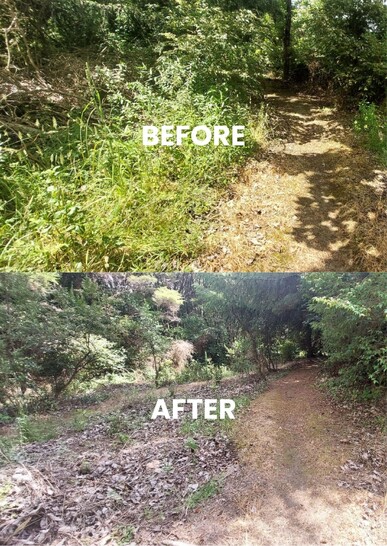
Tumutumu Kaitiaki te Taiao, environmental restoration project of Ngāti Tumutumu, are using photopoints as part of their monitoring programme to track their positive environmental impact over time.
The team have around 50 photopoints at the base of Mt Te Aroha, where weeds are most likely to enter the ngahere from private land. These photopoints offer a representative sample of the total 600-hectare project area which includes more than 1,000 pest plant sites.
Project Manager, Aaron Taylor, says without photopoints, they wouldn’t be able to show the full story of their impact.
“A lot of the areas [of treatment] were thick with weedy vines and had a lot of sunlight too. We found we were clearing the weed and it would grow back. Without the photopoints we can’t track how much has changed.”
Once a site is free of weeds, the team will often plant sun-tolerant native trees that whakapapa to the maunga - whether that be through propagation or seed-sourcing - to grow canopy cover to naturally suppress any further weed growth.
“This work [weed control and native planting] could be seen as a buffer, or protection, to stop weeds entering the maunga,” says Aaron.
Photopoints are a relatively easy and low-cost way to measure impact over a landscape. Learn more about them here.